



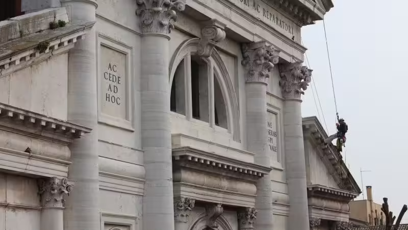

With its canals, bridges and historic buildings, Venice has an extraordinary architectural legacy. But preserving many of its most treasured monuments presents a growing challenge.
In recent years, floods have damaged historic structures across the city, including the iconic St. Mark’s Basilica and other UNESCO World Heritage sites.
Venice’s lagoon environment presents challenges for the preservation of historic buildings. Persistent moisture and salt can gradually weaken stonework and mortar, while the city’s complex foundations and the age of its structures can create additional vulnerabilities.
But innovative technologies could help detect signs of damage and aging earlier, to protect the city’s heritage before it is damaged irreparably.
For centuries, the Church of San Francesco della Vigna has been part of Venice’s remarkable architectural landscape. Its distinctive façade, designed by Renaissance architect Andrea Palladio, and its bell tower are among the defining features of a historic complex.
A recent survey employed digital methods, including drone photography and terrestrial laser scanning, to capture the church’s architecture in three dimensions. Researchers have combined that digital documentation with archival research and structural analysis, creating a detailed model that can help identify vulnerable areas and support future conservation work.
“These tools transformed how engineers, architects, and restorers interact with the monument,” said Ilaria Forti, the architect leading the project, who also teaches in the restoration, survey and digital drawing laboratory at the University Iuav of Venice.
The church was designed by Italian Renaissance architect Jacopo Sansovino and completed in 1554, with a façade added later by Palladio. After specialists found parts of the façade at risk of detaching in the 1990s, it was stabilized and restored.
Yet visible damage tells only part of the story of a building’s condition. Understanding how its materials and structure are aging, and identifying areas that may need attention, are essential to planning future conservation, Forti told CNN.
Forti’s work at San Francesco della Vigna followed an earlier conservation project at another Venetian church, Santa Maria di Nazareth, near the city’s railway station. From 2015 to 2022 Forti led restoration work on its Baroque façade, where the Carrara marble had deteriorated under the effects of the lagoon environment.
After completing the restoration, Forti approached the University Iuav of Venice to develop a monitoring program. This led to a collaboration with its VIDE Lab, directed by Professor Giuseppe D’Acunto and operated by research fellow and engineer Irene Rocca.
The experience provided a foundation for the project at San Francesco della Vigna, which began in 2023. This time, the researchers wanted to document the building’s condition before further conservation work began, rather than monitoring the results of an intervention that had already taken place.
“The order of the Franciscan friars asked us to run a monitoring campaign,” Forti said. “And so it was a perfect timing to combine our research.” The work was supported by the Venice in Peril Fund, following the interest shown by the Association of International Private Committees for the Safeguarding of Venice.
“Traditional inspection methods, like ground-based visual checks or limited scaffolding, often miss micro-fissures, structural shifts in high-altitude zones, and internal material failures,” Forti said.
Drone photography allowed researchers to reach areas of the façade and bell tower that would be difficult to inspect from the ground. But flying the drones in Venice brought an unexpected challenge.
“There’s so many seagulls around. And they really took these drones as a threat,” said Jonathan Hoyte, a climbing restorer who carried out inspections and repairs using rope-access techniques. “Sometimes you couldn’t even fly them because they’d start trying to attack the drones. So it wasn’t so simple.”
Photogrammetry, using overlapping photographs taken from different angles, was used to reconstruct the building’s surfaces in three dimensions. It was coupled with laser scanner technology that measures depth and distance directly, recording three-dimensional spatial coordinates.
“Laser scanning is a technology that gives exactly the position of the point — in our case, the position of the façade, of the tower, of the statues, for example. And it also gives us their color, their texture,” Forti explained.
The digital mapping helped identify areas where stonework had deteriorated under the effects of Venice’s lagoon climate. The models provided further information about cracks and areas where structural stresses could be concentrated, including around decorative statues, cornices, and other projecting features.
By analyzing sections of the 3D model, the researchers found that the upper portion of the façade was leaning slightly. The team also used the model to assess the bell tower’s vulnerability to earthquakes, identifying potential structural weaknesses, including a tendency toward overturning.
Debra Laefer, a professor at New York University’s Tandon School of Engineering, who was not involved in the project, said advances in remote-sensing technologies have changed how specialists document historic structures.
“Moving to noncontact methods in the form of remote sensing, such as thermal, imaging, laser scanning, hyperspectral, has moved the field from point measurements to more holistic documentation,” she said.
The survey data was only the starting point. The researchers combined the digital measurements with historical records, information about the building materials and structural assessments to create a more complete picture of the church.
Using the 3D model as the base, the team built finite element modeling (FEM) — an engineering method that divides a structure into smaller parts to analyze numerically how it responds to forces and where stresses may concentrate. The method was used to investigate the structural behavior of complex features, including the church’s statues and other architectural elements.
This information was then incorporated into a digital model that goes beyond a visual reconstruction of the building and contains information about areas of potential vulnerability.
“Now we have a digital twin, and for the future, for the next generation, we can have a database, a place of support for possible future intervention,” Forti said.

Luigi La Rocca, head of the Department for the Protection of Cultural Heritage (DiT) at Italy’s Ministry of Culture, agreed that monitoring technologies can reveal information that would not otherwise be detectable by a simple visual survey of the artifact. “Consider, for example, the data provided by sensors relating to the stresses and movements to which a structure is subjected,” he said.
But creating a detailed digital record is only part of the process. Turning that information into practical conservation plans and 3D models requires the expertise of architects, engineers and specialists, said Aylin Orbasli, a professor at Oxford Brookes University’s School of Architecture, who wasn’t involved in the Venice project.
The church’s façade is also distinguished by two monumental bronze statues depicting Moses and St. Paul, created by Tiziano Aspetti. Their intricate shapes made it particularly challenging for the team to produce accurate digital models. The researchers worked with statuary expert Professor Gabriella Liva at the LAR Lab, Iuav, to explore how other representations of Moses and Paul could help establish the geometry of the figures.
Researcher Irene Rocca, under the supervision of Professor Anna Saetta at Iuav, used finite element analysis to examine how the bronze statue of Moses responds to its own weight. The analysis identified a concentration of stress around the ankle, where the supporting area narrows, but the calculated stress remained below the strength limits of the bronze.

The digital survey method had practical benefits for the specialists working on the church. For Hoyte, whose company Extreme Woks uses rope-access techniques to monitor the building, having a scientific picture of its condition helped him determine which areas to inspect and how best to approach the work.
“Knowing that to go here instead of there, it really saves time and energy to put the ropes exactly where they need to be,” he said.
The drone survey also revealed vegetation growing in parts of the building that would have been difficult to reach. On the bell tower, the team even spotted blackberry bushes growing near the top.
Hoyte and his colleagues treated the plants before returning several weeks later to remove them and their roots. They then used mortar to seal the joints where the vegetation had been growing.
While photographs and 3D models can help identify areas that need attention, they cannot fully replace a close physical examination of the materials. “You might see cracks, but in order to understand if those cracks are completely at risk or not, you need to go and touch them,” Hoyte said.
The researchers hope the digital reconstruction will become more than a record of the church’s current condition. Data showing how the building responds to events such as strong winds or earthquakes, for example, could eventually be incorporated. The idea is to ensure that future conservation specialists can build on the work already completed.
“In conservation, I think it’s important not to start every time from zero,” said Rocca. “In this case, we have a lot of information, a lot of work already done.”
Long-term monitoring can also help specialists determine how historic buildings respond to changing environmental conditions. “Longitudinal data,” Orbasli said, “can support our understanding of what is happening to the building fabric under different climatic conditions. This is becoming increasingly important with climate change.”
But the technologies also bring practical challenges. Orbasli said the cost of the equipment, the volume of generated data and the computing power needed to process it can make their use difficult, particularly in regions with limited digital infrastructure. “It is by no means an equal playing field,” she said.
Laefer identified further challenges in managing the large amounts of information generated by digital surveys, including preserving datasets for future comparison and combining information from different types of sensors. “The main limitations today are systematic data archiving, data processing, as the files can be very large, and combining multiple sensor outputs,” she said.
La Rocca pointed to similar problems. The Ministry is trialing integrated monitoring, which brings together information from different technologies. “This methodology enables us to address scenarios characterized by multiple risks, even in the presence of differing environmental and cultural conditions,” La Rocca said. “The same technologies can also be used to carry out rapid damage assessments following emergency events.”
What sets the San Francesco della Vigna project apart, Forti said, is the collaboration between different areas of expertise. Bringing together engineering, architectural conservation and historical research allows the team to look at the monument from different perspectives and build a more complete understanding of its condition.
“The innovative part was to use them combined, all of them together, and to use them for the digital twin, and to use them for the assessment,” Forti said.
Source: www.cnn.com