



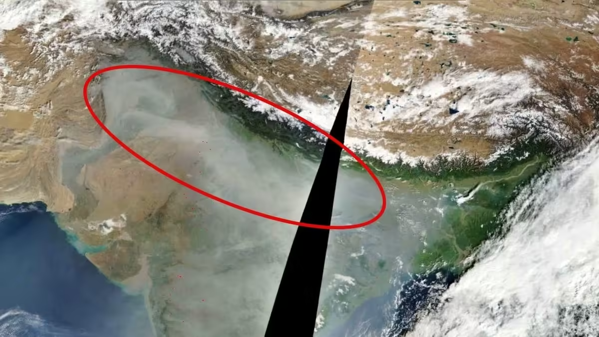

A massive blanket of haze and smoke stretching across northern India and Pakistan has been captured from space by a NASA satellite, offering a stark view of the worsening air pollution crisis as winter sets in across the region.
The satellite image, captured by the Moderate Resolution Imaging Spectroradiometer (MODIS) and made available through NASA’s Fire Information for Resource Management System (FIRMS), shows a thick greyish layer of haze spreading across the Indo-Gangetic plains, extending from Pakistan through northern India towards the eastern parts of the country.
The haze is particularly visible across Punjab, Haryana, Rajasthan, Uttar Pradesh and adjoining regions, with the Himalayan mountain range standing out in the northern part of the image.
The contrast between the snow-covered mountains and the pollution-laden plains highlights the vast geographical spread of the atmospheric haze.
The image also shows several red markers indicating detected fire hotspots, including areas across the northwestern agricultural belt. These detections are consistent with ongoing agricultural residue burning, which contributes to seasonal pollution across the region.
Every winter, northwestern India and neighbouring Pakistan experience a sharp deterioration in air quality as multiple pollution sources combine with unfavourable meteorological conditions. Stubble burning, vehicular emissions, industrial activity, construction dust and other sources add to the pollution burden.
The situation becomes particularly severe when colder temperatures, calm winds and a shallow atmospheric boundary layer prevent pollutants from dispersing. Instead, emissions accumulate close to the ground, creating persistent layers of smog across densely populated regions.
Delhi-NCR has been among the worst affected areas, with air quality deteriorating sharply during the night and early morning hours. However, the satellite image indicates that the pollution problem extends far beyond the national capital, affecting a much larger stretch of the Indo-Gangetic plains.
NASA’s MODIS instrument aboard its Earth-observing satellites provides wide-area observations of the planet, helping scientists monitor fires, atmospheric conditions, vegetation and changes on Earth’s surface.
The latest image shows that winter pollution is not confined to individual cities. It is a regional atmospheric problem, with emissions and weather systems interacting across national boundaries to create a vast pollution belt over South Asia.
– Ends
Source: www.indiatoday.in