




Summary
Parts of the western Alps got another solid shot of snow over the weekend, but all eyes now shift to the pattern change expected this week. A long-duration storm cycle will bring several days of snow this week, with substantial accumulations expected in the western Alps. Snow levels start high, but will gradually lower throughout the storm cycle.
Short Term Forecast
Many parts of the western Alps did well over the weekend, with 20 to 40 cm above 1800 m. This was just an appetizer to the main event this week, though. In the northwestern Alps, there will be little to no break between storms, as the jet stream strengthens and extends across the Atlantic. As the jet stream approaches western Europe, snow levels will climb as it pushes a weak ridge over southern Europe with warm southwest winds. The flow is expected to turn more westerly, though, around Tuesday night, allowing snow levels to come down a bit.
With the initial push of warm air, snow levels will climb above 2400 m on Tuesday. As the jet stream nudges farther east into western Europe, westerly flow will start to bring snow levels down a bit, to around 1800 m to 2100 m on Tuesday night, and 1500 m to 1800 m on Wednesday.
Below, you can see the snow level forecast for Chamonix. Notice the spike on Tuesday, followed by a gradual cooling throughout the week. The individual lines represent different snow level forecasts from a variety of models, which show us the range across the models. Overall, the spread is fairly small, with the warmest models keeping snow levels around 1800 m through Thursday, before falling a bit lower. On the lower end, the colder models bring snow levels down below 1500 m on Wednesday, and even lower later in the week.
Meanwhile, moisture from the atmospheric river will move into the western Alps courtesy of the strong jet stream, but, as you can see below, the heavier precipitation is not expected until Tuesday or Tuesday night. The figure below shows the total precipitation expected over the next five days in Chamonix. The range across models is between 90 mm and 180 mm during this time.

For snow, the models show a range of 80 cm to 160 cm through Friday.

Given the prolonged westerly flow from the powerful jet stream extending across the Atlantic, and the healthy moisture tap from the ocean, I expect big totals from this storm. Two upper-level lows will bring better dynamics at times, along with cooler temperatures.
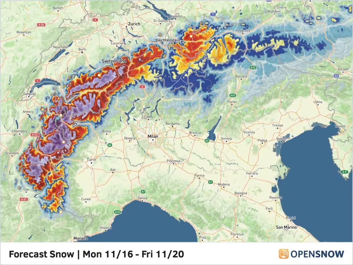
The latest snow forecast from the OpenSnow blend shows a wide area of 75 cm +, with locally 1 to 1.5 m above 2100 m for much of the western and northwestern Alps. This includes much of the northern French and the western and central Swiss Alps. Farther east, 30 to 60 + cm is possible in the eastern Swiss and western Austrian Alps. Areas typically favored by westerly flow will do well, with totals dropping off sharply across the border into Italy. It’s always a bit daunting to post a snow forecast of 1 to 1.5 m over a five-day period, but this setup certainly has the potential.

Of course, winds will be howling for much of this period, increasing avalanche danger and worsening snow quality. Visibility will be a nightmare above treeline during this stretch. Overall, though, this big storm will set up a huge number of resorts to start the season.
Extended Forecast
The models show a quick-hitting storm later this weekend, which could bring another round of accumulating snow to the western Alps. Beyond that, the models are mixed. Some bring additional chances for snow in the middle of next week, and then again the following weekend, while others stay mostly dry.
Next update on Wednesday.
Thanks for reading the Europe Daily Snow.
Luke Stone
Forecaster, OpenSnow
Announcements
2026-2027 Winter Release
We are excited to announce the following features and innovations, created in-house by our small team at OpenSnow.
These new features are currently available on the OpenSnow iOS app and website (OpenSnow.com). They are in development for the Android app and will be available soon.
Details: 2026-2027 Winter Release
Alps Regions:


Source: opensnow.com