• Home  
  • I made Karachi, Lahore, Islamabad take the 10-minute park test
I made Karachi, Lahore, Islamabad take the 10-minute park test
- World

I made Karachi, Lahore, Islamabad take the 10-minute park test

The ten-minute park test asks whether people can reach a public park or playground on foot from their homes. Its purpose is to identify neighbourhoods without everyday access to recreation and help direct investment towards them. In its population-based form, the score is the proportion of residents living within that walking distance. It tells us

The ten-minute park test asks whether people can reach a public park or playground on foot from their homes. Its purpose is to identify neighbourhoods without everyday access to recreation and help direct investment towards them. In its population-based form, the score is the proportion of residents living within that walking distance. It tells us something that the amount of green on a satellite image cannot: whether public open space is within reach of the people who need it.

The international examples are instructive. In the United States, Trust for Public Land reports that 100 per cent of San Francisco residents and 99 per cent of New Yorkers live within a ten-minute walk of a park. In Los Angeles, the figure is 62 per cent. These examples suggest that density need not prevent widespread access to parks.

This approach prompted me to run an exploratory test for Lahore, Karachi and Islamabad, using OpenStreetMap streets, paths and mapped green spaces. This exercise measures the share of mapped street and path length within an 800-metre walking route of a counted park. (It does not yet measure the proportion of residents served, so its percentages cannot be compared directly with the American figures. Nor does it measure tree cover, shade or the quality of a park.)

The results are 41 per cent for Lahore, 38 per cent for Karachi and 35 per cent for Islamabad. Within those totals, access to parks of at least ten acres accounts for just six, four and six per cent, respectively.

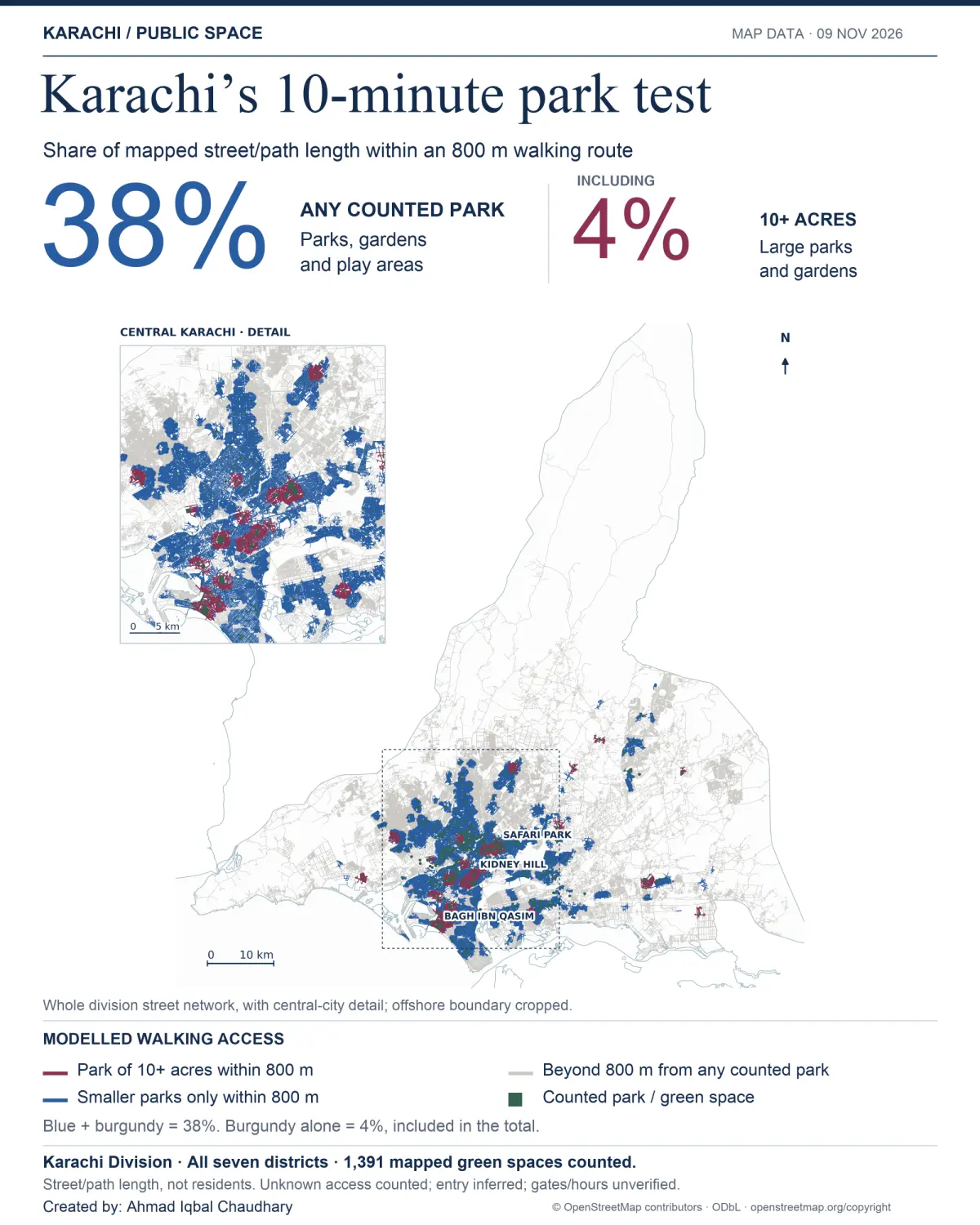
Karachi: An exploratory model estimates that 38% of mapped street and path length across Karachi Division’s seven districts lies within an 800-metre walking route of a counted park, garden or play area. This includes 4% within reach of a park of at least ten acres. The inset shows central Karachi in greater detail. The maps were re-rendered from the archived geographic data; these are not enlargements of the social-media images.

These estimates use generous assumptions: spaces with unspecified access were included, entrances were inferred, and gates, opening hours, fees and crossing conditions were not comprehensively verified. Missing parks or paths can also depress the estimates. The boundaries cover Lahore district, Karachi’s seven districts and Islamabad Capital Territory, excluding Rawalpindi. Rural roads and hill paths affect the results. These are preliminary access maps, not a ranking of resident experience. Eight hundred metres can also take considerably longer than ten minutes for a child or someone with limited mobility.

Lahore’s map shows how much its older urban fabric still contributes. The inner city and areas around the Walled City retain close relationships between neighbourhoods and gardens. Earlier planned suburbs, including Model Town and Gulberg, preserve pockets of this character. The larger-park access clusters around places such as Greater Iqbal Park, Bagh-i-Jinnah, Jilani Park and Model Town Park show the enduring value of setting aside substantial public space.
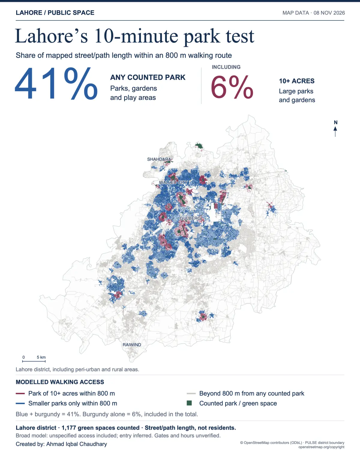
 Lahore: An exploratory model estimates that 41% of mapped street and path length in Lahore district lies within an 800-metre walking route of a counted park, garden or play area. This includes 6% within reach of a park of at least ten acres. The maps were re-rendered from the archived geographic data; these are not enlargements of the social-media images.
Lahore: An exploratory model estimates that 41% of mapped street and path length in Lahore district lies within an 800-metre walking route of a counted park, garden or play area. This includes 6% within reach of a park of at least ten acres. The maps were re-rendered from the archived geographic data; these are not enlargements of the social-media images.

But a major destination park cannot replace a neighbourhood playground. Karachi’s four per cent figure for large-park access makes that distinction especially relevant. Families need places children can use after school without requiring a journey across the city.

Lahore’s outward expansion raises a question about the kind of city we are building. As farmland gives way to housing schemes and roads, longer distances and disconnected streets can make routine activities dependent on motorised travel. Preserving the city of gardens requires land-use decisions that put homes and public spaces within walking distance.
Islamabad illustrates how road design can undermine that relationship. Doxiadis’s masterplan has its critics, but it recognised the importance of neighbourhood parks, playgrounds and pedestrian routes. For families living in small houses or flats, a public park provides space they cannot purchase within their own boundaries. The presence of greenery does not compensate for a road network that makes reaching it difficult.

Islamabad’s Fatima Jinnah Park (F-9) should be an everyday resource for residents of the G sectors across Jinnah Avenue. In January 2026, reporting documented the difficulties faced by G-9 residents crossing the road while a pedestrian underpass remained unfinished. The report concerned a specific construction period, but the planning question is lasting: can a child, an older person or a wheelchair user reach a park entrance safely and directly?
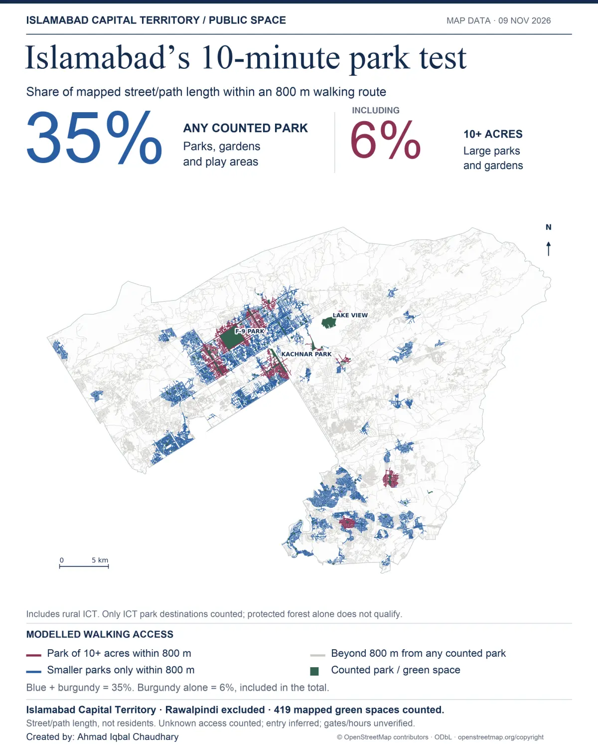
 Islamabad: An exploratory model estimates that 35% of mapped street and path length in Islamabad Capital Territory lies within an 800-metre walking route of a counted park, garden or play area. This includes 6% within reach of a park of at least ten acres. Rawalpindi and park destinations outside ICT are excluded; rural ICT routes remain included. The maps were re-rendered from the archived geographic data; these are not enlargements of the social-media images.
Islamabad: An exploratory model estimates that 35% of mapped street and path length in Islamabad Capital Territory lies within an 800-metre walking route of a counted park, garden or play area. This includes 6% within reach of a park of at least ten acres. Rawalpindi and park destinations outside ICT are excluded; rural ICT routes remain included. The maps were re-rendered from the archived geographic data; these are not enlargements of the social-media images.

The New Blue Area commercial ambitions make this question more pressing. Roads that facilitate driving while imposing detours and danger on pedestrians create a social barrier. Public investment should not make Islamabad’s amenities easier to enjoy for those with cars while making them harder to reach for those without.

Politicians, bureaucrats and planners too often assess the city from a moving vehicle. This is urban planning through the windshield: a signal-free road appears to be progress, while the loss of a safe pedestrian crossing goes unnoticed.

There have been significant investments in a different direction. In my opinion, current Prime Minister Shehbaz Sharif deserves credit for advancing modern mass transit through Lahore’s Metrobus, the Rawalpindi–Islamabad and Multan systems, and the Orange Line project. Chief Minister Maryam Nawaz’s expansion of Punjab’s public bus fleet, including electric buses, builds on that direction. Affordable, reliable public transport can be a powerful equaliser, widening access to employment, education and recreation.

That investment needs to extend to the walk at either end of the journey. Bus stops and park entrances should connect to continuous footpaths and safe crossings. New development should reserve usable public space close to homes, while existing neighbourhoods need smaller parks and playgrounds alongside major destinations. Greater density around public transport can shorten distances, provided public-space provision grows with the population.

Cities should now improve these preliminary maps with verified entrances, public-access conditions and population data, and use them to direct spending towards underserved neighbourhoods. Every road project should be assessed for its effect on walking access before construction begins. Public transport and public space will serve as equalising investments only when people can reach them safely.

Measure and legend

The percentages measure mapped street/path length, not the percentage of residents, land area, tree cover or shade. The large-park figure is included in the total, not added to it.


Blue: routes served by smaller counted parks only within 800 metres.

Burgundy: routes with a counted park of ten acres or more within 800 metres.

Grey: routes beyond 800 metres from any counted park.

Green: counted park or green-space footprints.

The broad model includes spaces with unspecified access and inferred entrances. Gates and opening hours are unverified. It does not establish the safety, quality or practical accessibility of every route or park. Missing parks and paths can also affect the estimates. Administrative boundaries include rural areas. The figures are not directly comparable with population-based ten-minute park-access scores.

Credit and attribution
Map and analysis: Ahmad Iqbal Chaudhary.
Base data: © OpenStreetMap contributors, Open Database Licence (ODbL).
Lahore district boundary: PULSE.

(function () {
var me = document.currentScript || document.scripts[document.scripts.length – 1];
var wrapper = me && me.closest(‘.raw-html-embed-wrapper’);
var source = wrapper && wrapper.querySelector(‘script.raw-html-source’);
if (!source || wrapper._rawHtmlMounted) return;
wrapper._rawHtmlMounted = true;

// position:sticky breaks under any overflow:hidden ancestor. “clip” hides the same overflow
// without creating a scroll container.
for (var a = wrapper.parentElement; a; a = a.parentElement) {
var cs = getComputedStyle(a);
if (cs.overflowX === ‘hidden’) a.style.overflowX = ‘clip’;
if (cs.overflowY === ‘hidden’) a.style.overflowY = ‘clip’;
}

// Undo the server-side escaping of closing script tags / comment openers.
var html = source.textContent.replace(/<(\\+)(\/script|!–)/gi, function (m, slashes, token) {
return '<' + slashes.slice(1) + token;
});
source.remove();

// iOS Safari kills tabs that hold many large base64 images: turn them into blob: URLs.
// blob: URLs work inside the srcdoc frame because it inherits our origin.
html = html.replace(/data:(image\/[\w.+-]+);base64,([A-Za-z0-9+\/=]+)/g, function (m, type, b64) {
if (b64.length < 4096) return m;
try {
var bin = atob(b64), bytes = new Uint8Array(bin.length);
for (var i = 0; i frame.clientHeight ? scroller.scrollHeight : root.getBoundingClientRect().height);
pinned = h > window.innerHeight;
if (pinned) {
stage.style.position = ‘sticky’;
stage.style.top = ‘0’;
fillScreen(stage);
track.style.height = h + ‘px’;
max = Math.max(0, h – frame.clientHeight);
} else {
// Grow only: vh-based content would otherwise shrink with its own frame, forever.
fitH = Math.max(fitH, h);
stage.style.position = ‘static’;
stage.style.height = fitH + ‘px’;
track.style.height=”auto”;
max = 0;
}
sync(true);
}

// inside the frame would only scroll the (non-scrollable) frame. Scroll the page instead.
function onAnchorClick(e) {
var link = e.target.closest && e.target.closest(‘a[href^=”#”]’);
if (!link || e.defaultPrevented) return;
var id = link.getAttribute(‘href’).slice(1);
try { id = decodeURIComponent(id); } catch (x) { }
var target = id ? doc.getElementById(id) : null;
if (id && !target) return;
e.preventDefault();
var inFrame = target ? target.getBoundingClientRect().top + win.scrollY : 0;
window.scrollTo({
top: track.getBoundingClientRect().top + window.scrollY + (pinned ? Math.min(inFrame, max) : inFrame),
behavior: ‘smooth’
});
}

frame.addEventListener(‘load’, function () {
try {
win = frame.contentWindow;
doc = win.document;
var ro = new win.ResizeObserver(measure); // created in the frame’s realm
ro.observe(doc.documentElement);
if (doc.body) ro.observe(doc.body);
doc.addEventListener(‘click’, onAnchorClick);
measure();
} catch (e) {
// No script access to the frame: fall back to a plain scrollable frame.
win = null;
frame.removeAttribute(‘scrolling’);
stage.style.position = ‘static’;
fillScreen(stage);
track.style.height=”auto”;
}
});

fillScreen(stage);
fillScreen(track); // placeholder until the frame has loaded and been measured
window.addEventListener(‘scroll’, function () { sync(false); }, { passive: true });
window.addEventListener(‘resize’, measure);

stage.appendChild(frame);
track.appendChild(stage);
wrapper.appendChild(track);
})();

Source: www.dawn.com

About Us

Toolq Media Is a Global News Platform Covering the Latest Developments and Breaking Stories from Around The World, Including World News, Business, Finance, Technology, Health, Politics, Science, Entertainment, Sports, and More.

Toolq

Toolq @2026. All Rights Reserved.