



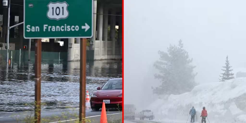

A powerful storm is pushing into the West, delivering rain, snow, storms and even a flash flood threat to parts of California. Whiteout conditions are possible across the Sierra Nevadas on Wednesday afternoon, and coastal areas of California will see several inches of rain and potential flooding.
THE TAKEAWAY
- San Francisco and Los Angeles face midweek flash flood threat from the latest atmospheric river storm.
- The Sierra Nevada is expected to see feet of snow into late this week.
- Malibu officials are advising residents to evacuate due to the threat of mudslides and debris flows.
- Relentless atmospheric river pattern shows no signs of letting up.
A relentless atmospheric river weather pattern is blasting the West Coast with repeated storms as the latest storm system threatens both the San Francisco and Los Angeles metro areas with flash flooding this week in addition to substantial snow across the Sierra.
This follows a weekend of storms that lasted into Monday, part of a prolonged atmospheric river that set up over the region nearly two weeks ago and shows no signs of budging.
FOX Weather Senior Correspondent Robert Ray shares an exclusive analysis on the impending stormy conditions for the Western U.S., with an atmospheric river fueling widespread rain and strong wind gusts.
The heavy rain will shift south into Thursday, with a Level 2 flash flood threat for the Los Angeles metro area. Areas around wildfire burn scars will be particularly vulnerable to flooding and debris flows.
With that threat in mind, the City of Malibu issued an evacuation warning for areas within the Palisades and Franklin fire burn zones beginning at 6 p.m. PST Wednesday.
Between Wednesday and Thursday, 30 million Americans will be under the highest level 2 flash flood threat.
The newest atmospheric river storm began moving over the California coast Tuesday night.
Unlike the first system, which was driven primarily by a broad corridor of moisture, this storm features a more concentrated area of low pressure and stronger upper-level energy, the FOX Forecast Center said.
SUPER EL NIÑO COULD BE SHORT-LIVED AS MAJOR WEATHER PATTERN SHIFT BRINGS LA NIÑA INTO FOCUS
NOAA’s Weather Prediction Center (WPC) issued a Level 2 flash flood risk for the Bay Area on Wednesday, which could see between 2 and 3 inches of rain.
Ahead of the flooding threat, the San Francisco Fire Department issued a warning to its residents about lithium-ion battery-powered vehicles and e-bikes, e-scooters, etc.
SAFETY MESSAGE: As the City and County of San Francisco prepares for the next round of storms, the Fire Department wants to deliver a safety message regarding lithium ion battery powered vehicles and micro mobility devices: If you believe that you have driven a lithium ion powered vehicle or mobility device through standing saltwater, the San Francisco Fire Department is directing you to store this device or vehicle outside of your home. Salt in the water may act as a conductor for electricity should water enter the battery casing of your device or vehicle. This salt could cause thermal runway and start a fire.
— SAN FRANCISCO FIRE DEPARTMENT MEDIA (@SFFDPIO) November 17, 2026
This storm could also pack wind gusts between 40 and 60 mph along the coast.
A Severe Thunderstorm Warning issued for San Mateo County, California, on Wednesday afternoon led to downed trees in Half Moon Bay, according to CAL FIRE CZU.
(FOX Weather)
Additionally, this system is forecast to produce substantial snow across the Sierra.
“Winter Storm Warnings are now in place for over 5 feet of snow at the highest peaks and over 1 to 3 feet of snow above 4,000 feet,” the FOX Forecast Center said. “Snow levels may drop to low as 3,000 feet where only a couple of inches of snow is possible.”

(FOX Weather)
More difficult travel conditions are expected across the California mountain passes through Thursday.
FOX Weather Senior Correspondent Robert Ray reported from Northern California’s Sierra Nevada as snow traveled through the mountains.
The Sierra Nevada is seeing snow from an atmospheric river storm that is pushing onshore. Feet of snow are possible throughout the mountains in California.
From there, this system will move inland, spreading rain and snow into the Great Basin and Rockies.
Weekend storm recap
Storms this weekend brought hurricane-force wind gusts and dangerous beach conditions along the coast from Washington to Southern California.
High surf damaged the wharf in Capitola, California, and prompted evacuation warnings. The beach remains closed due to damage and an ongoing E. coli investigation.
An atmospheric river storm dumped snow across parts of northwestern California on Monday, Nov. 16, 2026.
Video from social media showed snow falling across Highway 89 in Trinity County, in northwestern California.
Places around Tahoe tallied nearly 10 inches of snow over the weekend. Washoe, Nevada, recorded 14 inches of snow.
Check back for updates on this story.
Source: www.foxweather.com